Khoor, a city with rich and prolific cultural background, is the capital of Khoor& Biabanak region which is located in the vicinity of Isfahan . Though its history and formation process is not clearly known, clues such as few old parchments imply its existence back to 4th and 5th century of Islamic calendar. Khoor is the farmost point in the eastern border of Isfahan province and it is directly adjacent with other provinces like Khorasan, Yazd and Semnan
.
In Zoroastrian language Khoor is the guardian angel for the sun and it is also used as a synonym for the sun and its light. Biabanak on the other hand is the rather latter name for an ancient region in Dasht-e Kavir[1] and it is also assigned to a town. Biabanak region is an old one (nearly the same as today`s Khoor& Biabanak) in the southern border of Dasht-e Kavir which was located on the route connecting Isfahan (Naeiin) to Khorasan (Neishaboor).
In fact Biabanak is a part of an old and huge desert that Arabic resources call it "Mefaza"[2]. There are clues showing that this region was residential even before Islam, the most important of which might be a fire temple near Mehrejan (Mehranjan). More over in the same region Jandagh is famous as a prison related to Anooshirvan [3] and it has a dome called "Hasht darb" which is related to the Sasanian period.
Access path to the region
The asphalt-road of Khoor to Tabas reaches the southern part of the lake after 50 Km and because of the marshiness of nearby lands and even some parts of the lake itself, no other access is suggested. In order to drive on the surface of the lake or so, it is highly recommended to follow a local guide
Dasht-e Kavir
Dasht-e Kavir (däsht-ēkävērˈ) [
key], great salt desert, c.500 mi (800 km) long and c.200 mi (320 km) wide, SE of the Elburz Mts., N central Iran. It is a huge basin of interior drainage named after the kavirs (salt marshes) located there. The Kavir Buzurg (Great Kavir), c.200 mi (320 km) long and c.100 mi (160 km) wide, lies in the heart of the region; low sandy hills separate it from smaller kavirs. An almost rainless climate with strong surface evaporation has created a crust of salt over the marsh and mud lands. Chemical salts balance the evaporation by drawing moisture from the substrata and the atmosphere. Because its kavirs have properties similar to quicksand, travel in the Dasht-e Kavir is extremely dangerous. It is almost uninhabited and only partly explored; settlement is restricted to the hills and surrounding mountains. Extending S from the Dasht-e Kavir is the
Dasht-e Lut,
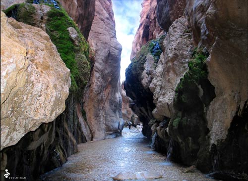
Desert or salt marsh is a land in which according to the profusion of salt no crop can be farmed or cultivated. Of course in some regions some kinds of plants live, but these plants are not crops and they are not edible but mostly they are used for industrial purposes or they are used to feed animals like goats and camels. In other word desert is a place with no water or greenery. Anyway, a huge part of Iran is consisted of deserts like Loot Desert , Yazd desert Tabas desert etc. each of which includes smaller deserts in itself. Some tourists travel to these deserts just for enchanting and delightful visions. These people take refuge in the mysterious silence of the desert, haunting the traditional mud-made houses or Caravanserais, watching the stars (as desert is the place to watch the sky and the stars far from dust layers of the cities etc.) and going up and down the soft sandy hills, to have a joyful and calm experience. Others however, prefer a more adventurous journey as the sandy hills, roads and plains of the desert are very convenient for racing rallies and other exciting events.
The village of Mesr
The village of Mesr is located within 45 kilometers to the east of Jandagh and 45 kilometers to the north of Khoor. Its geographic position is 04.34 degrees north latitude and 47.54 degrees east latitude. Because the village is located in the south of the big desert its weather is hot and torrid and according to the latest census its population is about 120 persons and they earn their living by husbandry. Saffron and wheat are the main crops of the village. The village is equipped with communication center (PTT) and electricity is provided by a diesel generator
.
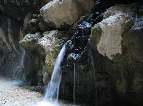
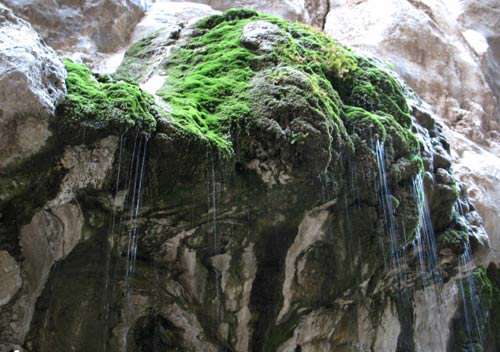
-Within 2kilometers of the village the Amir Abad region with its dunes and its divers plant coverage, including palms and Gaz trees, reveals great natural beauties. -Farahzad village, in the north of Mesr, contains palm forests surrounded by dunes. -Reed-brake of Mesr, 6 kilometers to the north-east of Mesr, is created by the water coming from a beautiful spring. The reed-brake includes tall reeds some of which reach the height of 4meters or more. The spring also plays the role of a main water source for animals of the region
يك كارشناس ارشد توسعه روستايي با بيان اينكه توريسم روستايي با هدف ديدن و بهرهمندن شدن از طبيعت، زيباييها و جاذبههاي متنوع محيط طبيعي روستاها انجام ميگيرد، گفت: توريسم روستايي در ايران ميتواند به عنوان ابزاري براي توسعه روستاهاي هدف مورد استفاده قرار گيرد.


 l
l


 ر
ر
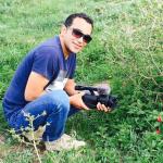
 محمد ملا حسن زاده یکی از مجرب ترین راهنمای های محلی در طبس می باشد که بر تمامی نقاط تاریخی و طبیعی طبس اشراف کامل دارد و در سفر گردشگران به این منطقه بسیار مفید واقع خواهد شد . در سفر های طبیعت گرددی وجود راهنمای محلی حرفه ای بسیار مفید می باشد زیرا هم در وقت و هزینه شما صرفه جوی خواهد شد چون در صورتی که در این سفرها مسیر اشتباهی طی شود باعث از دست زمان بسیار زیادی شد و چه بشا ممکن شما روزی را کامل از دست داد و به سفر شما یک روز اضافه شود . راهنمای محلی بخاطر آشنای با مناطق و مردم بومی در بسیاری از موارد سفر باعث سهولت و احساس آرامش خاصی به گردشگر میدهد.
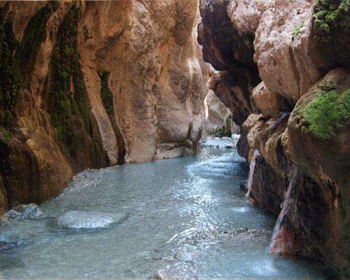


 وبلاگ هتل بالی جهت اطلاع رسانی در مورد هتل بالی خور و مناطقی از کویر مرکزی ایران ایجاد شده است وبرای ارتقا صنعت گردشگری کشور وحمایت از جوامع محلی از هر گونه تلاش دریغ نخواهد کرد